 Glossary
 Resources
Resources
Search
The search found 21 results in 0.1 seconds.
Search results
-
Water quality monitoring
(FR) - OFB
This webpage introduces the water quality monitoring programs developed in France, as a requirement of the WFD
Theme : Data and maps
-
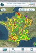
"Water quality" application
(FR) - Onema & Agences de l'Eau 2016
This new smartphone or tablet application allows to obtain information on the river status: "very good", "good" or "poor"; information of a...
Theme : Data and maps
-
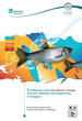
Freshwater fish and climate change: current situation and adaptation strategies
(EN) - Onema 2014
This document gives an overview of the current knowledge about observed and predicted changes of climate and hydrology, and about the impact of...
Theme : Diagnosing > Documents
-
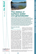
The status of surface water and groundwater
(EN) - Onema 2015
After giving some contextual elements about the water-status assessment system in France, some data and maps are proposed about the chemical and...
Theme : Data and maps
-
Naïades
(FR) - AFB
The national interface, Naïades, provides access to data from national monitoring of rivers and lakes. This data is targeted on biological,...
Theme : Data and maps
-

Portal for National Migratory Fish Data (Ponapomi)
(FR) - AFB 2018
This participatory portal offers a centralized access to data on migratory fish in metropolitan France, as well as links to resources and to...
Theme : Data and maps
-
Guide to the interpretation of the scales and the estimation of the age of brown trout (Salmo trutta) from the French populations
(EN) - OFB 2020
A user manual for interpreting the scales and estimating the age of brown trout (Salmo trutta).
Theme : Diagnosing > Documents
-
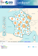
CartOgraph
(FR) - OFB
Tool for visualizing and exploiting a large number of data relating to water, aquatic environments and their uses in the form of maps, graphics...
Theme : Data and maps
-
The ICE method for ecological continuity - Assessing the passage of obstacles by fish and macro-crustaceans in the French tropical islands of the Atlantic and Indian Oceans - Concepts and design
(EN) - OFB 2021
An adaptation of the Information on the Continuity of Ecosystem (ICE) method to the tropical islands of Guadeloupe, Martinique, Mayotte and...
Theme : Diagnosing > Documents
-
Dataviz – Learn more about flow barriers
(FR) - OFB 2019
Different graphic representations illustrating flow barriers data: obstacle types, height, uses…
Theme : Data and maps